November 24, 2010
The relentless flat landscape has changed. We’re now in the Central Ranges Schwerin Mural Crescent Range to the north and the Petermann Ranges
At the bottom of the quarry are two ruddy coloured water holes. Temperatures are still peaking at around 40˚ so the first thing we do after setting up camp is descend on the water holes, ignoring their murky muddiness and jumping in. They’re only a foot or so deep and the bottom is lined with silky soft mud, which I rub on my skin as I float across the pond; my skin feels very soft when it dries.
Our next thought is to scale a nearby peak. The old adventurers in us remember the challenge of spying a distant destination, and setting off to attain it. But our age, the intense heat, Johan’s back pain, and a too-light lunch all slow us down and we decide to call it enough when we reach the base of the peak at around 6pm, 2kms from camp. It’s a wonderful walk through the bushlands though and makes me ponder what it would have been like for explorers who first traversed this area over a hundred years ago.
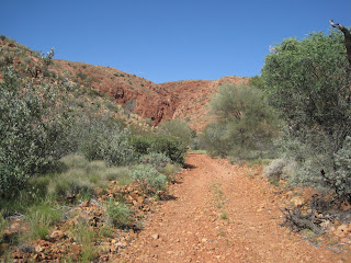
The next day we follow a cryptic reference to a “very impressive waterhole” in our guidebook, 27kms down a side road. There are no further directions and no signage, but at the 27km mark, we spy a narrow track leading off to the range we’ve been driving alongside. A few kilometers in and the track ends in a lush canyon area. We leave the car unlocked, keys in the ignition and go exploring up the canyon. Not far in we encounter the first water hole, clearly being fed by a watercourse further up. When we arrive at the apex of the canyon, the deep waterhole, ringed by massive sheer red cliffs, is too inviting to pass up. Off go the clothes and in go we -- such refreshment! An awesome idyllic setting. We hang for over an hour, sitting in silence, watching birds, hearing the wind echo through the rocks. It doesn’t get much better than this.
Down a dusty track
...which ends at a beautiful canyon...
...with a stunning water hole...
...and Aboriginal rock art.
Back on the Central Road Northern Territory Docker River
There’s a cache at the location up on top of a rocky outlook – a hot and sweaty climb in the mid-afternoon sun. Another breathtaking view and chance to drink in the expanse of the desert.
There are several options for camps another 100kms along. It’s been a long driving day and we’re tired, hot and a bit snappy with each other. But the camps are too plain after last night’s experience, so we head further down the track, towards Kata Tjuta, the Olgas. When they first appear, giant round red bobbins jutting unexpectedly out of the flat landscape, it takes our breath away. There’s a momentary surreal sense of being in alien territory, on another planet. They’re blindingly beautiful.
We take a jag down an unposted dirt track and find a good-enough spot with an open view to the southwest, the Olgas just peeping up over the horizon. We watch as their colours change continuously with the setting sun.
A hungry looking dingo.


No comments:
Post a Comment